The day didn’t start with any warning.
It was the late 1990s, and Captain Phil had run offshore out of Key West countless times before. The plan that morning was simple: head east into the Atlantic, find blue water, and chase fish. Conditions were calm, visibility was good, and nothing about the weather suggested the kind of turn the day was about to take.
Back then, offshore navigation wasn’t what it is today. There were no full-color chartplotters or real-time vessel tracking systems. Most boats relied on a mix of compass headings, paper charts, experience, and a LORAN-C unit mounted at the helm. LORAN worked well enough—if you understood it. It gave you position lines based on radio signals, which you interpreted and plotted. It could get you close. Usually close enough.
That distinction—close enough—matters more than it sounds.
The fishing was decent early. Not spectacular, but steady enough to keep them working. Lines were out, the boat settled into its rhythm, and there was no reason to rush. Like a lot of offshore days, it felt routine in the best possible way.
The fog didn’t drift in gradually. It built quickly, almost without notice. One moment there was a visible horizon, and the next it had softened into haze. Within minutes, that haze thickened into something heavier, until sky and water blurred together into the same flat gray.
Then the horizon disappeared entirely.
Phil pulled the throttle back and took a slow look around. There was nothing to orient against—no shoreline, no sun, no variation in the water. Just a uniform wall of fog in every direction. It wasn’t just low visibility. It was the absence of reference.
They made the right call immediately and decided to head back.
The problem was that heading back assumes you know exactly where you are.
The LORAN unit was still giving readings, but LORAN required interpretation. You weren’t following a moving dot on a map. You were reading coordinates, translating them, and trusting that your understanding of your position was correct. Normally, you’d confirm that with visual cues—the angle of the sun, the look of the water, distant land or markers.
Now there was nothing to confirm anything.
Phil set a course based on his best read and began running on dead reckoning—tracking direction, speed, and time to estimate position. It’s a method that has worked for centuries, but it depends on small assumptions being correct. A slight current, a minor heading error, or a misjudged speed can slowly pull you off course. Without visual feedback, those errors compound.
At first, it was just an uncomfortable situation.
Then it became something else.
The first sign was a sound that didn’t stand out right away. It blended into the background—something like distant surf or a swell breaking unevenly. In open water, that kind of noise isn’t unusual. It didn’t trigger alarm immediately.
But it kept building.
Phil listened more carefully, trying to place it. The tone was wrong for wind and wrong for waves, but it was close enough to both that it didn’t immediately register as anything else.
Then the fog parted just enough for the truth to appear.
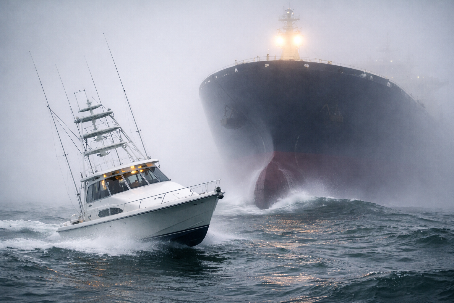
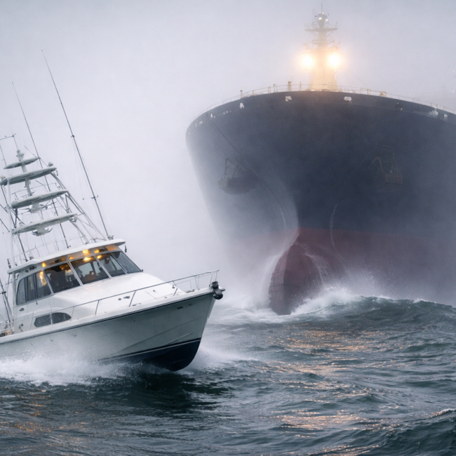
A freighter emerged out of the gray at close range—far closer than anything that size should ever be without warning. Its bow cut through the water with slow, heavy force, pushing a wall of ocean ahead of it. The sound they had been hearing wasn’t the sea. It was that displacement—the water breaking off the front of a massive ship.
Phil reacted instantly, turning hard to clear its path. The boat moved just enough to avoid it, and then the ship was gone again, swallowed back into the fog as quickly as it had appeared.
That’s when the situation came into focus.
They weren’t just lost in fog. They were in a shipping lane.
Those lanes off Key West are major corridors, with large vessels moving at steady speed and limited ability to maneuver quickly. In clear weather, you can see them miles out and adjust accordingly. In fog like this, you don’t see them until they’re already on top of you.
The second ship confirmed it.
Same sound. Same sudden appearance. Same last-second adjustment.
At that point, the priority shifted completely. It wasn’t just about finding land anymore. It was about getting out of that lane before one of those encounters didn’t leave enough room.
Phil adjusted course with that goal in mind, choosing a direction that should take them across the lane rather than along it. It wasn’t a guarantee. Without visibility, even determining the orientation of the lane involved some guesswork. But staying put or continuing blindly carried its own risks.
They held that new heading and waited.
After several tense minutes, the sounds stopped. No more low, rolling displacement that didn’t match the sea. No more shadows forming in the fog. Whether by navigation or luck, they had cleared the worst of it.
The fog, however, didn’t let up.
And that’s when the next problem surfaced.
Fuel.
The extra maneuvering, the uncertainty, and the time spent correcting course had burned more than expected. When Phil checked the gauge, it was lower than it should have been for a clean run back.
They weren’t out, but they were no longer comfortable.
Phil had reserve fuel stored below deck—something he kept for situations exactly like this. He brought it up and transferred what he could, buying them additional range. It helped, but it didn’t solve the larger issue.
They still had to pick the right direction.
This was the real decision point of the day. Without visibility, without reliable confirmation of their exact position, Phil had to choose a heading that he believed would take them back toward the Florida coast.
There was also a real possibility it wouldn’t.
Under those conditions, even an experienced captain could be working with incomplete information. Later, Phil estimated there was a significant chance—something like 70 percent—that the initial heading could have been wrong. Not because he didn’t understand the situation, but because the fog had stripped away every external reference point that normally reinforces those decisions.
If the heading was wrong, the consequences were straightforward. They would be running farther out into the Atlantic instead of back toward land, burning fuel in the process. Even if they corrected later, they would no longer be heading toward the closest point. They would be recovering from a mistake, and that costs distance and fuel.
They could have called for help on the radio. It was an available option, and this wasn’t yet an emergency in the strict sense. But it was a situation that demanded a decision, and Phil made one.
He set the course and committed to it.
What followed was a long run through featureless gray. Time stretched in a way that only happens when there’s nothing to measure distance against. The engine became the only constant—steady, reliable, and finite. Phil made small, deliberate corrections, avoiding any large adjustments that might introduce more error.
Without confirmation, everything came down to judgment and consistency.
Gradually, the fog began to thin. Not all at once, but enough to change the texture of the world around them. The gray light gained depth. The distance ahead stopped feeling completely flat.
Then a darker line appeared.
At first it was faint, almost easy to dismiss. But it held its shape as they moved forward. It grew more defined, more solid, until it was unmistakable.
Land.
The Florida coast.
They had chosen correctly—or at least correctly enough.
Even then, the situation wasn’t entirely over. The fuel was still low, and they still had to make it back to port without unnecessary detours. Now, finally, there were visual references again. Direction had meaning. Distance could be judged.
They kept the run efficient and direct.
By the time they reached port, they were running on fumes. Not as a figure of speech, but in the literal sense of having very little fuel left to spare. It was the kind of margin that gets your attention after the fact, when there’s time to think about how easily it could have gone differently.
In hindsight, it wasn’t a life-threatening situation. They had a radio. They had options. But it was still far beyond what anyone had planned for when they left the dock that morning.
More than anything, it marked the difference between two eras of navigation.
At that time, systems like LORAN could get you close, but they still left room for uncertainty. Experience filled the gaps, but it couldn’t eliminate them entirely. Today, GPS has changed that equation. Modern systems provide exact position, heading, and even the location of other vessels, including large commercial traffic.
The fog can still come in just as thick.
The difference is that now, it doesn’t take everything else with it.